River Profile - Riverscape Features | |
| Floura and Fauna | Riverscape Features | |
| Visit the main River Returns web site >> | |
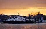 |
MayportThe "Jean Ribault," a car ferry named for the French Admiral who landed at the mouth of the river on May 1, 1562 and dubbed it "Rivere du Mai," crosses the St. Johns at Mayport, east of Jacksonville. Here, the once-lazy St. Johns meets the Atlantic Ocean in a swirl of crisscrossing currents. |
 © Karst Productions, Inc. |
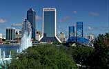
JacksonvilleJacksonville, the river city situated near the mouth of the St. Johns and at the crossroads of two interstate highways in northeastern Florida, is defined by bridges. A major port, it's the largest city in the contiguous United States in land area and ranks 14th nationally, with a burgeoning population of more than 800,000. |
 |
Mid-channel, Lower BasinSouth of Jacksonville, the St. Johns opens up and slows down, running sleek and wide: three-and-a-half miles across where the Julington Creek flows into it. Here, a wedge of tidal saltwater mingles with fresh. The shoreline is just a thin band of foliage hiding heavy residential and industrial development. |
 |
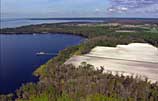
Racy Point AreaAbout 20 miles south of Jacksonville, the shoreline of the broad and relatively shallow St. Johns is dotted with homes and punctuated by long docks built to reach out for hundreds of yards into the deeper waters of the river. |
 © Karst Productions, Inc. |
Hastings AreaThe acres-upon-acres of farmland along the St. Johns in the Hastings area is obvious from above, but not immediately apparent to boaters on the river because of a swath of wetland fringe. Hastings, the state's potato capital, is situated in the Tri-County Agricultural Area. |
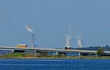 |
PalatkaThe cooling towers of a riverside power plant punch into a skyline defined by the Memorial Bridge along Route 17, a main artery into Palatka. Just south, the river's personality changes, growing markedly narrow as it twists into a classic oxbow and assumes a more leisurely demeanor. |
 |
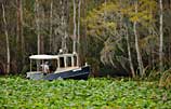
Seven Sisters IslandsAn aerial view shows a houseboat approaching a cluster of islands known as Seven Sisters, just south of Palatka. A convenient overnight camp for rental houseboats bound upriver from Palatka, the Seven Sisters affords river rats their first taste of "wilderness" - St. Johns style. |
 |
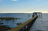
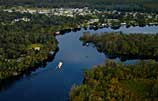
Welaka AreaBoathouses and docks have long been a common sight on this stretch of river, just north of the small town of Welaka, an historic steamboat landing on the east shore. These days, boaters use the river for everything from leisure cruising and water skiing to bass fishing. |
 |
OcklawahaPainstakingly restored in the style of the 19th-century craft once used to light channel markers, a vintage boat makes its way out of the Ocklawaha River into the St. Johns. This spring-fed tributary was the site of many a paddlewheel excursion in the river's heyday as a 19th -century tourist attraction. |
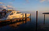 |
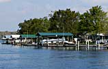
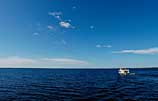
Georgetown MarinaKayaks and barges, and just about every kind of boat in between, ply the waters of the St. Johns. Moored at Georgetown Marina, this yacht's bow points toward the wide-open watery horizon of Lake George. At 6 miles across, Lake George is the widest spot in the river. |
 |
Drayton IslandThe thickly forested hammock known as Drayton Island is situated across from the Georgetown Marina, at the northern end of Lake George. A public ferry that holds two cars at a time serves this privately owned wilderness inhabited by only a handful of humans. |
 |
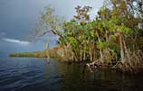
Mouth of Salt Spring RunA boat full of bass fishermen leaves the wide-open expanse of Lake George to try their luck in Salt Springs Run, a shallow 5-mile corridor of water that is brackish because of relic seawater bubbling up from the aquifer. The run is fringed by a unique array of marsh and swamp plants. |
 |
Salt Spring RunPaddlers quietly poke into the intriguing nooks and crannies of Salt Spring Run, which is buffered by the Ocala National Forest. Scrub forest plants, such as sand pines and myrtle oaks, line the grassy banks marking the natural progression of marsh into swampland. |
 |
Lake GeorgeThe second largest lake in Florida, Lake George is at times more like a small white-capped sea than a wide glassy river. It encompasses 72-square miles, virtually dwarfing all manner of watercraft that attempt to cross its 6-mile width or 12-mile length -- even behemoth houseboats. |
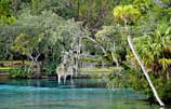 |
Silver Glen SpringProtected by sentry-like palm and cypress trees of Ocala National Forest, but accessible by boating up a short and deep, jungle-like spring run off of Lake George, Silver Glen is a first-magnitude spring. Clear, slightly salty water -- a relic from an ancient sea -- blasts out of the aquifer from deep caverns. |
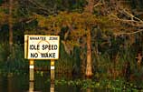 |
Lake Woodruff AreaUpriver of Lake George, the St. Johns narrows and makes its lazy way along the edge of the Lake Woodruff National Wildlife Refuge, a 97.5-square-mile stretch of wilderness managed for the benefit of creatures ranging from sandhill cranes to bobcats. Manatees also find some protection here, thanks to the regulation of boat speeds. |
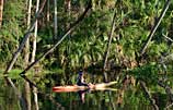 |
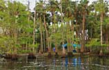
Blue Spring RunA lone kayaker paddles noiselessly under the moss-draped branches of live oaks, past the sun-dappled trunks of palms, hugging the bank opposite Blue Spring State Park. This refuge lures not only manatees, but humans as well, hoping to catch a glimpse of Florida's vestige wilderness. |
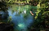 |
Headspring at Blue SpringAs the sun breaks through morning mist, a kayaker paddles out of the canopy-covered run and into the headspring basin of Blue Spring where clear water boils up from deep under the earth with spectacular force; this is a first-magnitude spring. |
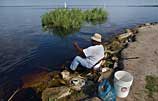 |
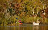
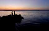
Lake MonroeA fisherman angles for panfish on the bank of Lake Monroe, a shallow 15-square-mile bulge in the St. Johns River. Saltwater fish sometimes find their way here on tidal currents even though it's 160 miles from the sea. Monroe's southern shore, located in the city of Sanford, is battened-down by bulkheads. |
 |
Lake Jesup AreaSabal palms fringe the main stem of the St. Johns River where it barely skirts the northeast tip of Lake Jesup, a murky green body of water that suffers from having been denied the river's cleansing currents due to canal and bridge development. Gators still thrive here, however; stingrays, too. |
 |
Wekiva RiverPaddlers and wildlife alike delight in a jungle-like canopy that arches over the Wekiva River. A thickly wooded cypress swamp makes for near-perfect bear habitat as it buffers this spring-fed tributary of the St. Johns from the frenetic growth and metropolitan pace of nearby Orlando. |
 |
Lake Harney AreaLake Harney is a 9.5-square-mile shallow pool in the St. Johns River surrounded by pickerelweed and bulrush. From here south, toward its headwaters, the river becomes a braid of channels slicing through marshland. Only small outboards and airboats can navigate these shallow, twisting sections of the river. |
 |
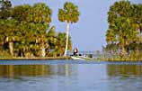
Lake WashingtonLake Washington, a shallow pool of water surrounded by a marshy shore, marks the end of a navigable channel of the St. Johns, and therefore can be mistaken as its headwaters. The river is born south of here in vast marshlands; just to the east is Interstate 95 and the city of Melbourne. |
 |
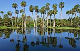
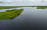
Spade IslandBetween Lake Washington and Blue Cypress Lake, the weed-choked St. Johns meanders through marshes and swamps that occasionally are punctuated by wooded hammocks. Spade Island, fringed by palms, is one of a number of wilderness camps in this area maintained by the St. Johns River Water Management District. |
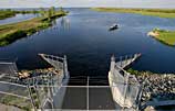 |
Farm 13This 6.25-square-mile reservoir, known as Farm 13, was formerly farmland until extensive drainage canals were plugged and the natural hydrology restored enough to re-flood some of the vast wetlands that give rise to the St. Johns River. Once planted with radishes, Farm 13 is now teeming with bass. |
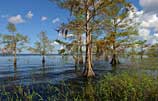 |
Blue Cypress LakeThe shimmering tannin waters of Blue Cypress clearly reflect both the sky and the bald cypress trees lining its shore, thus earning the lake its colorful name. The lake, a haven for fisherman, is surrounded almost entirely by wetlands; those to the south form the headwaters of the St. Johns. |
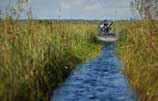 |
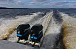
Airboat TrailAn airboat zips along a shallow water trail through a sawgrass marsh that is as remote and isolated as it is vast. Structurally and biologically similar to the better-known Everglades to the south, these marshes form the beginning of the St. Johns River's long and lazy northward trip to the sea. |
 © Karst Productions, Inc. |
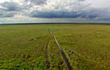
The River's HeadwatersMassive clouds spill five feet of rain annually on the vast marshes of this part of the St. Johns River's upper basin. Although the northward sheetflow of water is barely discernable this is where the St. Johns River begins its 310-mile journey to the sea. |
River Profile
The River Returns
Stories of the Great St. Johns

The Water's Journey: The River Returns film
is an original film by Karst Productions, Inc.
is an original film by Karst Productions, Inc.
The River Returns web documentary, Copyright © Fusionspark Media, Inc. All Rights Reserved.
All Photos © 2005 Russell Sparkman/Fusionspark Media, Inc., unless otherwise noted.
All Photos © 2005 Russell Sparkman/Fusionspark Media, Inc., unless otherwise noted.